Geography & Maps
Articles:
- "The Most Popular Map Of The World Is Highly Misleading" by Christina Sterbenz on "Business Insider," Dec 10, 2013
- "How the north ended up on top of the map" by Nick Danforth on "Aljazeera America," Feb 16, 2014
- "MapCarte 38/365: McArthur’s Universal Corrective Map of the World, Stuart McArthur, 1979" by Kenneth Field on "ICA Commission on Map Design," Feb 7, 2014
- "40 maps that explain the Middle East" by Max Fisher on "Vox," March 26, 2015
- "This incredible map shows the movement of every ship on the planet" by Will Martin on "Business Insider," April 28, 2016 (www.shipmap.org)
- "If Americans Can Find North Korea on a Map, They’re More Likely to Prefer Diplomacy" by Kevin Quealy in "The New York Times," May 14, 2017
- "Islamic State and the crisis in Iraq and Syria in maps" from "BBC News," April 7, 2017
- "Fascinating Set of 18 Maps" (If maps don't appear, try clicking on "tugboattimbo" near top of page) [unsourced & undated], Jan 17, 2017
- "5 ways of redrawing the U.S. electoral map that actually make sense" by Ana Swanson in "The Washington Post," Dec 19, 2016
- "What the U.S. map should really look like" by Ana Swanson and Jonathan O'Connell in "The Washington Post," Dec 12, 2016
- "These Maps Show How Vast New Infrastructure Is Bringing the World Together" by Parag Khanna on "Huffington Post," April 18, 2016
- "Six maps that will make you rethink the world" by Ana Swanson in "The Washington Post, April 29, 2016
- "15 Maps That Don't Explain the Middle East at All" by Nick Danforth in "The Atlantic," July 31, 2014
- "Imagining a Remapped Middle East," article by Robin Wright in The New York Times, September 28, 2013. (see also response from Rami G. Khouri)
- "The Daily Show" clip on mapping the Middle East.
- "West Wing" clip on the Peters Projection map.
- "The Afternoon Map: A Cartography Blog" (Because looking at history is easier than reading about it...)
- "A New Map for America" by Parag Khanna in "The New York Times," April 15, 2016
- McEvedy, Colin & Woodcock, John, The New Penguin Atlas of Ancient History: Revised Edition, 2003
- "How megacities are changing the map of the world," a Ted Talk by Parag Khanna, April 27, 2016
- "Mapping the Future of the World" - a Ted Talk by Parag Khanna, Sept 28, 2009
Maps
Trade
- The Silk and Spice Routes (UNESCO)
- Cities along the Silk Roads (UNESCO interactive map)
- New Silk Roads (Wall Street Journal, Nov 9, 2014)
- shipmap.org - interactive shipping map
Military Installations
- "Where in the World the U.S. Military Is Combatting Terrorism" from "Smithsonian Magazine," Jan 2019
- militarybases.com - interactive map of stateside and some overseas US bases with descriptions
- todaysmilitary.com - interactive map of U.S. military bases in the U.S., Eurasia, and the Pacific (not Africa)
- NATO on Duty - interactive map of NATO presence
- Russia's militarization of the Arctic
- U.S. Bases Surrounding Iran
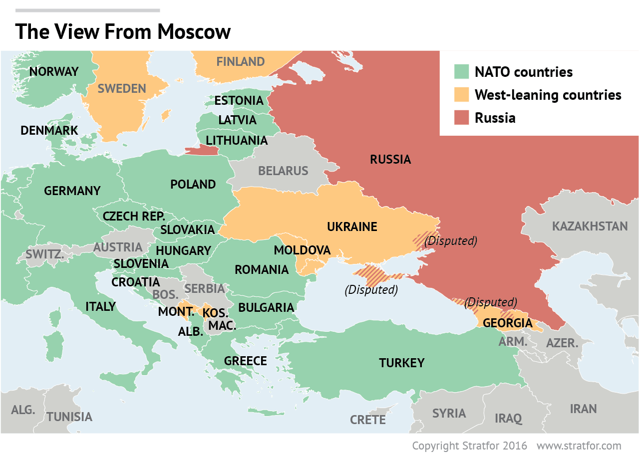
Maps of Russia Russia and the Former Soviet Republics (Perry-Castaneda Library)
China Maps
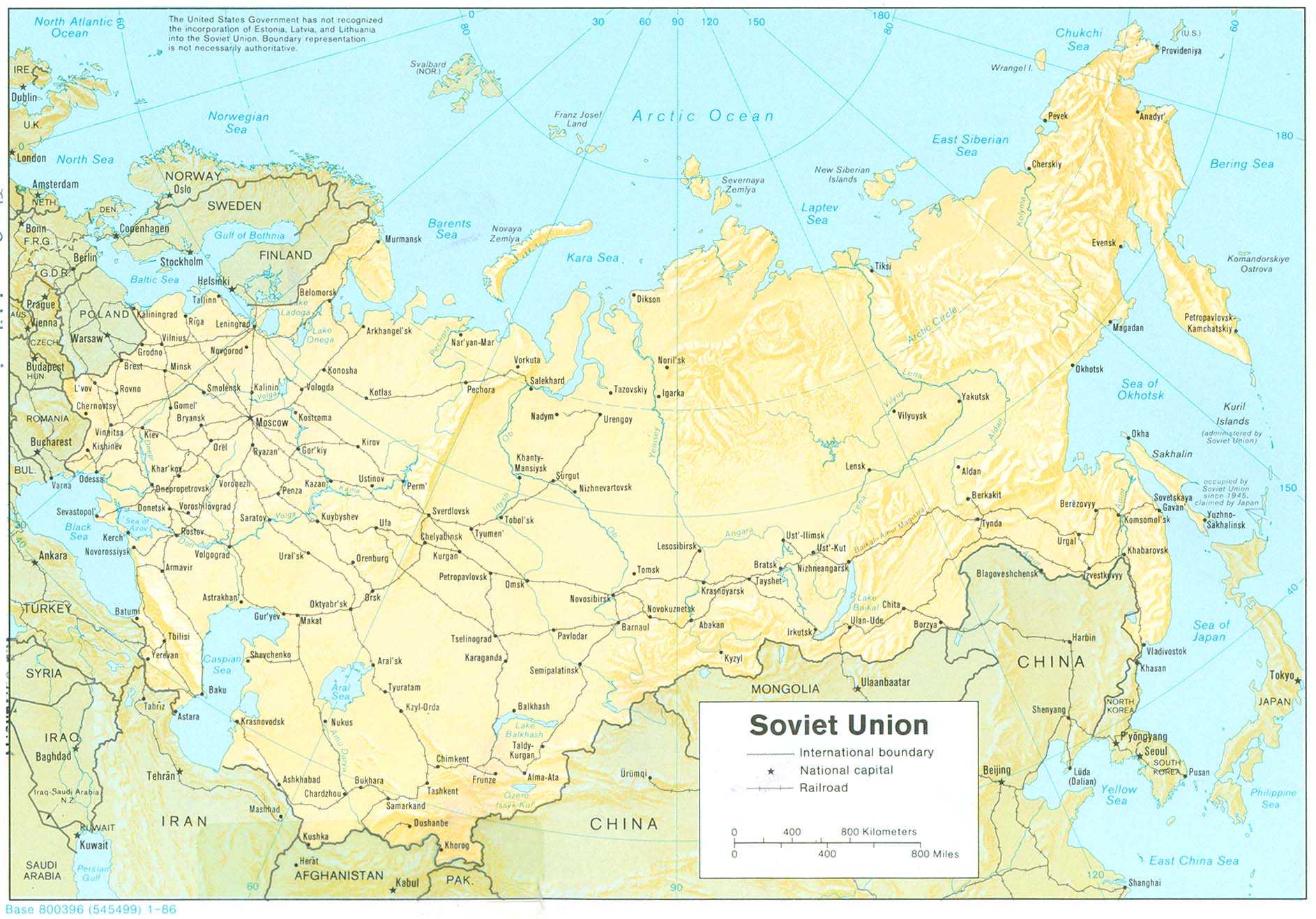
- Soviet Union (Shaded Relief) (1986)
- Russia (Shaded Relief) (1994)
- Ukraine (Shaded Relief) (1993)
- Muslim Peoples (1981)
- Muslim Population (1979)
- Ethnic Groups in Southern Soviet Union and Neighboring Middle Eastern Countries (1986)
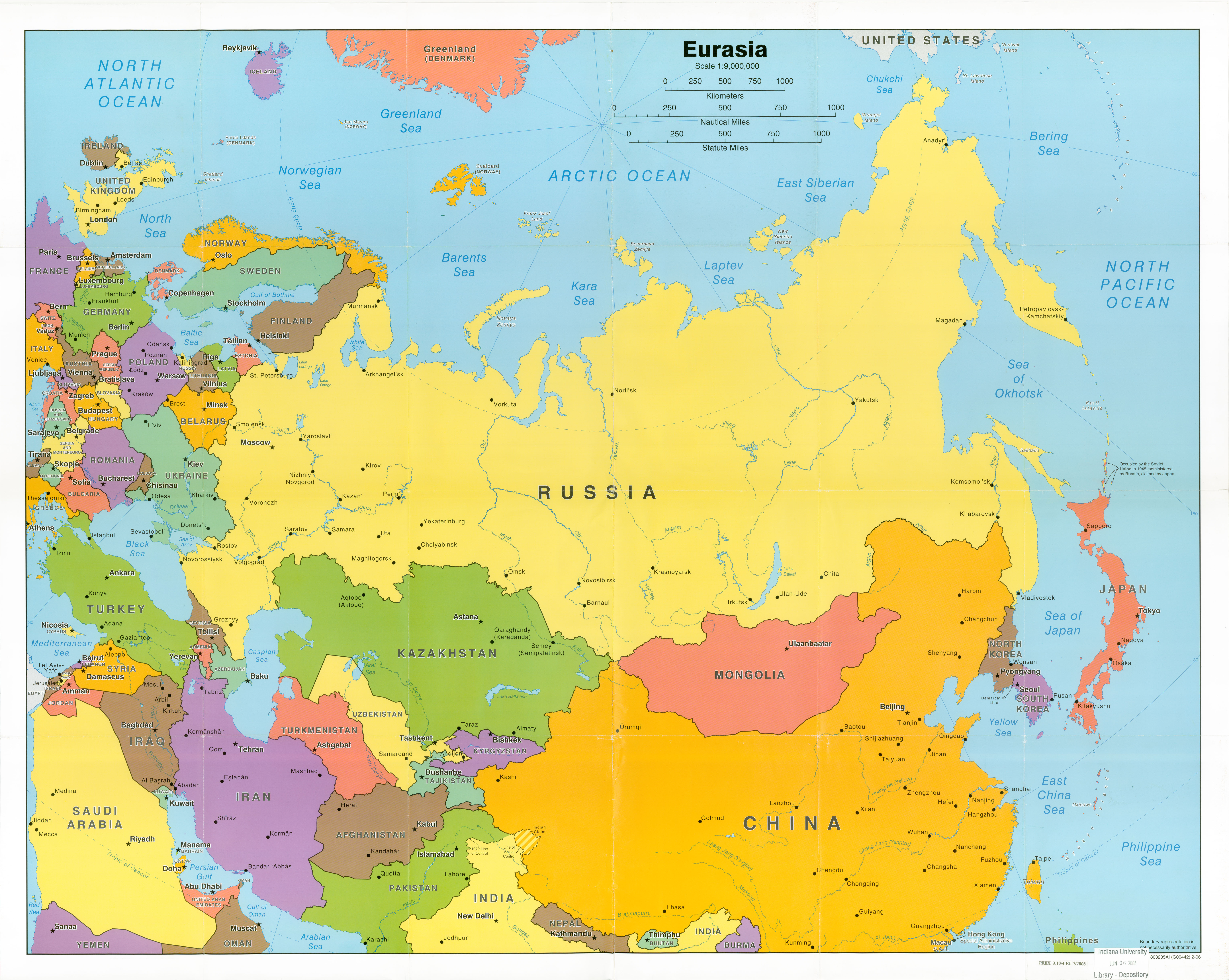
- Eurasia (2006)
China Maps
- South China Sea Nine-Dash Line
- Spratly Islands in the South China Sea
- Seven Voyages of Zheng He Between 1405-1433
- Ming Dynasty (Middle Kingdom) Domain 1368-1644 (with Imperial Chronology)
- Map comparing USA to Peoples Republic of China
- Map of Earlier & Later Han Dynasties (206 BC-220 AD)
- Map of Districts with Capitals
- Map of Communes (c. 1961)
- Map of Military Administrative Zones (c. 1960
- Map of the Qinghai-Tibet Railway
- Map of the People's Republic of China and Tibet
- Map of "...stans" and topographic map of Silk Road
- Old Maps of Syria
- Old Maps of Iran
- Old Maps of Egypt
- Old Maps of Turkey
- Old Maps of China
- Old Maps of Russia
- "The American Nations Today" from American Nations: A History of the Eleven Rival Regional Cultures of North America by Colin Woodard
- Kazakhstan Maps in the Perry-Castañeda Library Map Collection
- Yemen: Political Divisions from Ezilon.com, 2009 (best if printed landscape)
- Yemen: Who Controls What on "Al Jazeera," March 24, 2019
- 15 Overlay Maps That Will Change The Way You See The World by Diana Yukari on "Business Insider," April 14, 2017
- Fortinet Cyber Threat Map
- McArthur's Universal Corrective Map of the World
- "Fascinating Set of 18 Maps" (If maps don't appear, try clicking on "tugboattimbo" near top of page) [unsourced & undated]
- World Battleground, 1000 years of war in 5 minutes
- A Time-Lapse Map of Every Nuclear Explosion Since 1945 - by Isao Hashimoto
- "How 5 Countries Could Become 14," analysis by Robin Wright to accompany "Imagining a Remapped Middle East," article by Robin Wright in The New York Times, September 28, 2013.
- Links to maps on Juan Cole's Informed Comment blog
- History of the French Colonial Empire: 1550 to 2013 - an interactive map on youtube.com
- French Empire: 17th-20th Centuries - from Wikipedia.org
- North Africa & the Middle East (2009)
- Algeria Physiography (2001)
- Middle East Maps - "Next best thing to Mapquest - for the Middle East" - Interactive "drill-down" maps of the Middle East
- InfoPlease.com
- Perry-Castaneda Library Map Collection, University of Texas
- Click here for information about the difference between Peters Projection and Mercator Projection maps.
- True Size of Africa map by Kai Krause
- Kurdish Lands map produced by the CIA (1992)
- Kurdish Areas in the Middles East & Soviet Union map by the CIA (1986)